
Paper: GS – I, Subject: Geography, Topic: Physical Geography of India, Issue: Updated Coastline Length of India’s.
Context:
India’s coastline is now nearly 50% longer than before, not due to territorial expansion but because of more accurate recent measurements.
Key Takeaways:
- The number of islands has also slightly increased following a reassessment and recount of offshore islands.
- Recent reports from the Ministry of Home Affairs reveal that India’s measured coastline has increased from 7,516.6 km to 11,098.81 km a nearly 48% rise.
- This change is due to improved measurement techniques and a more comprehensive definition of maritime boundaries, not territorial expansion.
Shift in Measurement Scale:
Old Methodology (1970s): Coastline measured as 7,516.6 km.
- Used low-resolution maps (scale ~1:4,500,000).
- Coastal features like small bays, inlets, and estuaries were smoothed out.
- Resulted in a shorter, more linear coastline.
New Methodology (2023–24): Updated coastline length is 11,098.81 km.
- Based on high-resolution Electronic Navigation Charts (scale 1:250,000).
- Developed by the National Hydrographic Office (NHO).
- Utilized advanced technologies: GIS, LIDAR-GPS, drone imaging, and satellite altimetry.
- Captures detailed natural bends, curves, and irregularities of the coast.
Key Agencies Involved in Recalculation:
The comprehensive re-evaluation process involved a collaborative effort between several key government agencies:
- Survey of India (SoI): The national mapping agency responsible for surveying and mapping.
- National Hydrographic Office (NHO): Responsible for hydrographic surveys and nautical charting.
- Ministry of Home Affairs (MHA): The nodal ministry overseeing the official announcement and acceptance of the revised figures.
- National Maritime Security Coordinator: Guided the scientifically updated approach.
Implications of the revised Coastline data and recent Coastline Management initiative in India:
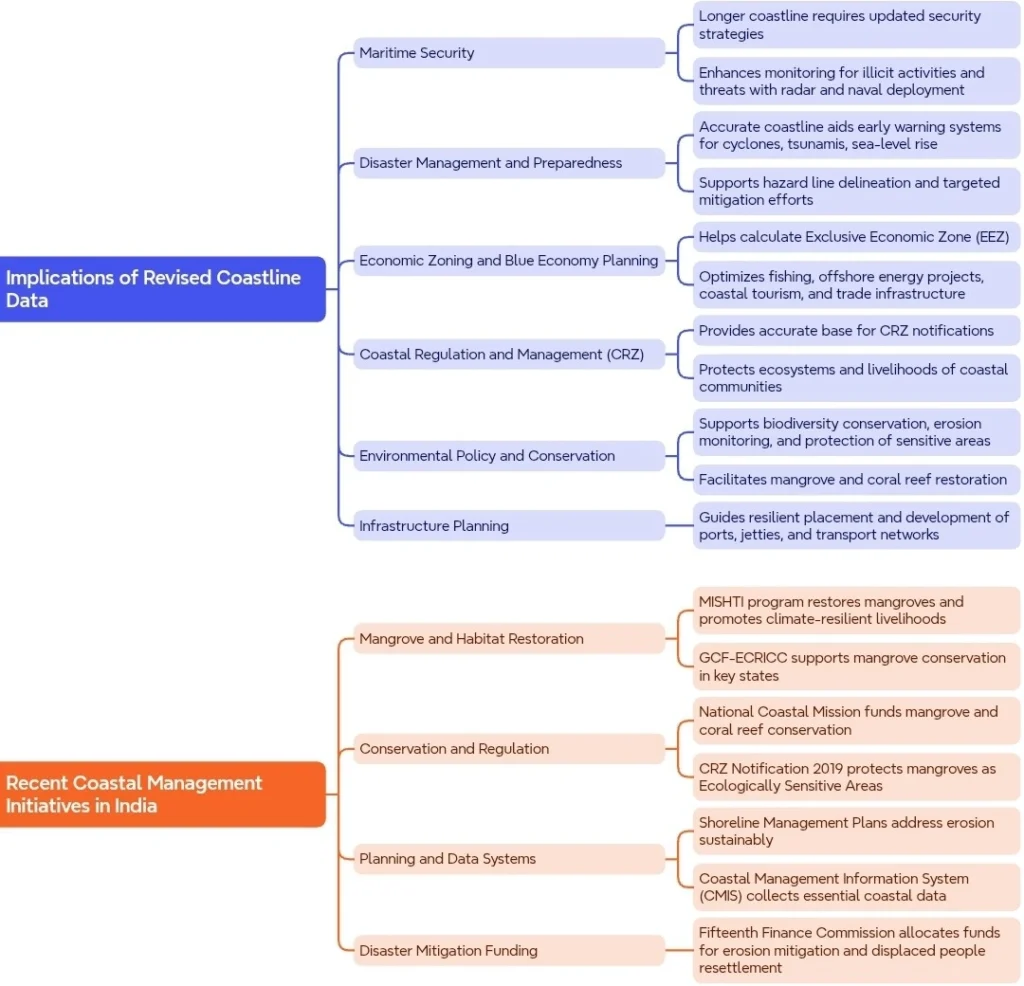
Conclusion:
- The reassessment of India’s coastline and the total number of islands reflects the importance of precise geographical data in understanding and managing national resources, coastal protection, and administrative complexities.
- The advancements in measurement techniques highlight the interplay between technology and geography, influencing both policy and developmental strategies.
https://indianexpress.com/article/explained/india-coastline-island-10078625/
La Excellence IAS Academy, the best IAS coaching in Hyderabad, known for delivering quality content and conceptual clarity for UPSC 2025 preparation.
FOLLOW US ON:
◉ YouTube : https://www.youtube.com/@CivilsPrepTeam
◉ Facebook: https://www.facebook.com/LaExcellenceIAS
◉ Instagram: https://www.instagram.com/laexcellenceiasacademy/
GET IN TOUCH:
Contact us at info@laex.in, https://laex.in/contact-us/
or Call us @ +91 9052 29 2929, +91 9052 99 2929, +91 9154 24 2140
OUR BRANCHES:
Head Office: H No: 1-10-225A, Beside AEVA Fertility Center, Ashok Nagar Extension, VV Giri Nagar, Ashok Nagar, Hyderabad, 500020
Madhapur: Flat no: 301, survey no 58-60, Guttala begumpet Madhapur metro pillar: 1524, Rangareddy Hyderabad, Telangana 500081
Bangalore: Plot No: 99, 2nd floor, 80 Feet Road, Beside Poorvika Mobiles, Chandra Layout, Attiguppe, Near Vijaya Nagara, Bengaluru, 560040