
Paper: GS – II, Subject: International Relations, Topic: India and Its Neighborhood, Issue: Indo-China Border.
Context:
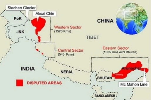
The India-China border dispute, particularly in the eastern sector involving Arunachal Pradesh, arises from historical complexities centered on the McMahon Line.
Key Takeaways:
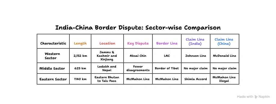
- The McMahon Line was drawn during the 1914 Simla Conference between British India and Tibet as an official frontier demarcation but was never accepted by China, leading to ongoing territorial tensions.
- This border remains sensitive due to strategic, ethnic, and geopolitical factors.
India – China Border Dispute:
- Relations between India and China are worsening as both countries face off along their disputed border in the Himalayas.
- The main issue is a poorly defined border that stretches 3,440 km (2,100 miles).
- Natural features like rivers, lakes, and snow caps can shift the boundary, leading to confrontations between soldiers.
- Also, both nations are competing to build infrastructure along this border, known as the Line of Actual Control.
- India’s construction of a new road to a high-altitude air base was a key trigger for a deadly clash in 2020.
| How serious is the situation? Despite ongoing military talks, tensions remain high. In December 2022, troops clashed for the first time in over a year near the Tawang sector in Arunachal Pradesh, resulting in minor injuries for some soldiers. Efforts to ease tensions have followed a major clash in June 2020 at Galwan Valley, where soldiers fought with sticks and clubs instead of guns. This was the first deadly confrontation between the two countries since 1975, with at least 20 Indian and four Chinese soldiers losing their lives. |
The total boundary shared between India and China is around 3488km (2nd highest after Bangladesh).
- The border is generally divided into 3 sectors namely Eastern, Western and Middle Sector.
- A total of 5 states share boundaries with China, Jammu & Kashmir, Himachal Pradesh, Uttarakhand, Sikkim and Arunachal Pradesh.
India – China Border Dispute:
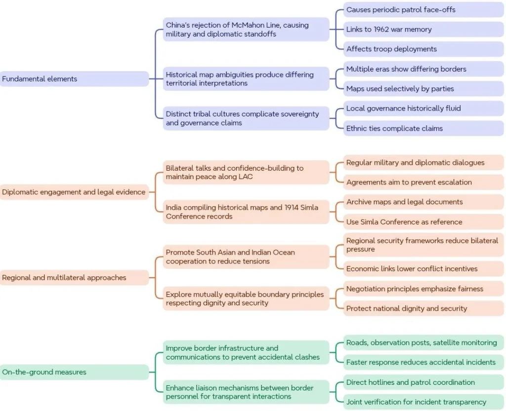
The India-China border dispute over Arunachal Pradesh stems from colonial-era boundaries, especially the contested McMahon Line. While India recognizes it, China disputes it, leading to ongoing tensions. Resolving the issue requires historical context, diplomacy, sensitivity to local complexities, and cooperative efforts. A peaceful settlement would strengthen bilateral ties and regional stability.
La Excellence IAS Academy, the best IAS coaching in Hyderabad, known for delivering quality content and conceptual clarity for UPSC 2025 preparation.
FOLLOW US ON:
◉ YouTube : https://www.youtube.com/@CivilsPrepTeam
◉ Facebook: https://www.facebook.com/LaExcellenceIAS
◉ Instagram: https://www.instagram.com/laexcellenceiasacademy/
GET IN TOUCH:
Contact us at info@laex.in, https://laex.in/contact-us/
or Call us @ +91 9052 29 2929, +91 9052 99 2929, +91 9154 24 2140
OUR BRANCHES:
Head Office: H No: 1-10-225A, Beside AEVA Fertility Center, Ashok Nagar Extension, VV Giri Nagar, Ashok Nagar, Hyderabad, 500020
Madhapur: Flat no: 301, survey no 58-60, Guttala begumpet Madhapur metro pillar: 1524, Rangareddy Hyderabad, Telangana 500081
Bangalore: Plot No: 99, 2nd floor, 80 Feet Road, Beside Poorvika Mobiles, Chandra Layout, Attiguppe, Near Vijaya Nagara, Bengaluru, 560040