
Paper: GS-I, Subject: Geography, Topic: World Geography – Map, Issue: Equal-Area Mapping and Territorial Concerns
Context
Recently, the United Nations General Assembly (UNGA) adopted the “Correct the Map” resolution by 164 votes to one. It encourages equal-area maps that represent the relative sizes of continents more accurately, particularly Africa.
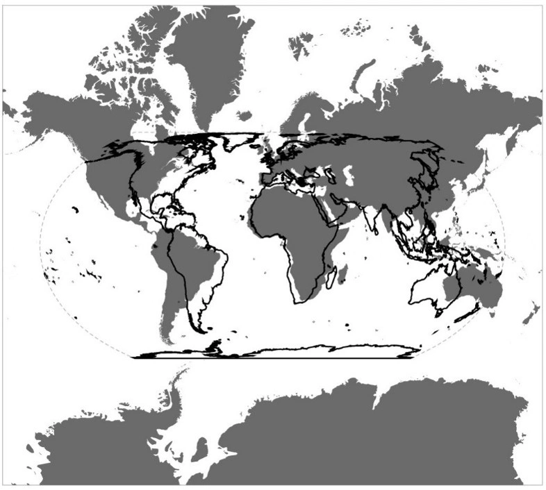
Background
- A map projection represents spherical Earth on a flat surface. Every projection distorts area, shape, distance or direction.
- Gerardus Mercator designed his projection in 1569 for navigation because constant compass directions appear as straight lines.
- Equal Earth was developed in 2018 by Bojan Šavrič, Tom Patterson and Bernhard Jenny as an equal-area projection.
Current Uses and Limitations of Mercator
- Mercator and its digital variant, Web Mercator, remain widely used for marine navigation and online maps. They preserve directions, while rectangular tiles enable zooming.
- However, scale increases poleward, making Greenland, Russia, Canada and northern Europe appear disproportionately large.
- Africa is nearly 14 times larger than Greenland, although both may appear similarly sized. Mercator enlarges high-latitude regions rather than shrinking Africa.
UN’s “Correct the Map” Resolution
- Togo introduced the resolution on behalf of the African Group, with support from the African Union.
- Equal-area mapping projection allows fairer comparisons of continents, populations, forests, agricultural land and natural resources.
- The resolution advances cognitive justice, meaning fairness in how geographical knowledge shapes perceptions of different regions.
Why the United States Opposed It
- The United States cast the sole opposing vote, arguing that references to “cognitive justice” and “memorial reparation” politicised a technical matter.
- It described the resolution as unnecessary and part of a “radical ideological project” distracting the UN from important responsibilities.
India’s Territorial Concern
- India supported equal-area mapping but clarified that its vote did not endorse any particular political map.
- A separate map prepared by UN Geospatial in 2026 placed Arunachal Pradesh and Aksai Chin between Indian and Chinese claim lines.
- India considers Arunachal Pradesh integral and Aksai Chin part of Ladakh. Projection concerns mathematical representation; political cartography concerns sovereignty and boundaries.
Limitations of the Cartographic Reform
- The non-binding resolution neither prohibits Mercator nor makes Equal Earth compulsory.
- Equal Earth preserves area but distorts shapes, angles, directions and distances. Therefore, no single flat map is suitable for every purpose.
Conclusion
Equal-area maps represent Africa’s geographical importance more fairly, while Mercator remains useful for navigation and digital mapping. Projections should be chosen according to purpose, without compromising national sovereignty or established territorial positions.
Source: (Down to Earth)
La Excellence IAS Academy, the best IAS coaching in Hyderabad, known for delivering quality content and conceptual clarity for UPSC 2026 preparation.
FOLLOW US ON:
◉ YouTube : https://www.youtube.com/@CivilsPrepTeam
◉ Facebook: https://www.facebook.com/LaExcellenceIAS
◉ Instagram: https://www.instagram.com/laexcellenceiasacademy/
GET IN TOUCH:
Contact us at info@laex.in, https://laex.in/contact-us/
or Call us @ +91 9052 29 2929, +91 9052 99 2929, +91 9154 24 2140
OUR BRANCHES:
Head Office: H No: 1-10-225A, Beside AEVA Fertility Center, Ashok Nagar Extension, VV Giri Nagar, Ashok Nagar, Hyderabad, 500020
Madhapur: Flat no: 301, survey no 58-60, Guttala begumpet Madhapur metro pillar: 1524, Rangareddy Hyderabad, Telangana 500081
Bangalore: Plot No: 99, 2nd floor, 80 Feet Road, Beside Poorvika Mobiles, Chandra Layout, Attiguppe, Near Vijaya Nagara, Bengaluru, 560040
Equal Earth Projection